
Let’s be brutally honest for a second—if you are scrolling through your social media feed right now, you are probably seeing endless videos of pristine, cloud-inversion sunrises from the top of Bali’s volcanoes. It looks magical, serene, and effortless. But here is the reality check: while some of those videos are from beginner-friendly trails, attempting a Mount Agung tour is an entirely different beast.
Trekking to Mount Agung is not a casual morning stroll; it is the most physically and mentally demanding topographical challenge on the island. If you are not prepared, it will absolutely break you. But if you have the stamina, the right private driver logistics, and the sheer willpower to push through the burning in your legs, it will reward you with the most profound sense of achievement you can find in Southeast Asia. In this comprehensive guide, we are going to strip away the marketing fluff and break down exactly what it takes to conquer the mt agung bali hike safely in 2026.
What is the Mt Agung Bali Hike?
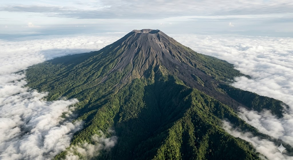
To truly appreciate the magnitude of what you are signing up for, you have to look beyond the trail itself. Mount Agung is not just a pile of rocks; it is a massive, towering stratovolcano and the absolute highest point on the island of Bali, piercing the sky at a staggering 3,142 meters (10,308 feet) above sea level.
When you commit to trekking to Mount Agung, you are stepping onto an active geological giant. The volcano’s origins are rooted in the complex tectonic subduction of the Indo-Australian plate beneath the Eurasian plate, which built this massive cone layer by layer through thousands of years of andesitic lava flows and pyroclastic ash. It is a living, breathing entity. Its last catastrophic eruption occurred in 1963—a massive event that devastated the region and reshaped the very crater rim you will be hiking toward. While it experienced a period of heightened unrest between 2017 and 2020, as of 2026, the Indonesian volcanological survey has classified Mount Agung at a Level 1 alert status (“normal”), meaning there are no active geological safety barriers preventing a climb.
The Spiritual Axis of the Universe
You cannot separate the physical Mt Agung Bali hike from its immense cultural weight. For the Balinese Hindu population, this is the most sacred ground on Earth. It is considered the terrestrial replica of Mount Meru, the central axis of the universe in Hindu cosmology.
According to ancient 15th-century manuscripts like the Tantu Pageleran, when Bali was an unstable island floating wildly in the ocean, the gods commanded the cosmic turtle and three mythical serpents to slice off the peak of Mount Semeru in Java and place it on Bali to anchor the land. That divine anchor became Mount Agung. It is the compass by which the entire island navigates; the directional concept of kaja means “toward the mountain,” and every temple, home, and shrine is oriented to face this sacred peak. When you hike here, you are not just a tourist in a national park; you are a guest walking through an ancient, sacred sanctuary.
The Microclimate and Ecological Zones
Because of its sheer size, Mount Agung creates its own weather system. As you ascend during your Mount Agung tour, you will physically feel the transition through multiple distinct ecological zones. You begin in dense, humid tropical jungles where the air is thick and the roots form natural, slippery staircases. As you push past the 2,000-meter mark, you enter an evergreen forest zone where the humidity drops and the air turns remarkably cold. Finally, as you break through the tree line, you are thrust into an exposed, harsh landscape of volcanic scree, loose gravel, and massive basalt boulders. This drastic environmental shift is what makes the Mt Agung Bali hike so uniquely challenging—you start sweating in a tropical jungle and finish shivering in alpine-like winds.
Why Trekking to Mount Agung is the Ultimate Achievement
You might be wondering, if it is so difficult, why do it? Why subject yourself to hours of agonizing climbing in the pitch black? The answer lies in the unparalleled exclusivity and the sheer magnitude of the reward.
Escaping the Festival Crowds
Here is a raw truth that brochures rarely tell you: the easier volcanoes in Bali are incredibly overcrowded. During peak season, alternative sunrise hikes can draw upwards of 200 to 300 people per morning. You are often hiking in a literal line of people, breathing in dust, and fighting for a spot to take a photo at the summit.
Trekking to Mount Agung filters out the crowds through sheer physical difficulty. The intense demands of the Mt Agung Bali hike mean that only a handful of serious, dedicated hikers make the attempt each night. When you reach the top, there is no festival atmosphere, no shouting, and no fighting for space. It is just you, your guide, a few other exhausted but elated climbers, and the sweeping silence of the high-altitude winds.
The Unmatched Panoramic Payoff
Because Mount Agung towers over everything else on the island, the view from the top defies description. You are literally standing above the clouds. As the sun breaches the horizon, it paints the sky in violent shades of purple, orange, and red. You can look down and see the entire island of Bali spread out like a miniature map. To the east, the sun rises directly behind the jagged peaks of Mount Rinjani on the neighboring island of Lombok. To the west, on a perfectly clear morning, you can even spot the smoking cone of Mount Raung in Java. You also get to stare directly down into the massive, plunging caldera of the volcano itself—a humbling reminder of the mountain’s explosive power.
The Badge of Honor
Completing a Mount Agung tour is a massive physical and mental flex. When you tell locals or seasoned expats that you successfully summited Agung, you instantly earn a different level of respect. It proves you have genuine fitness, immense grit, and the mental fortitude to keep moving when every muscle in your body is screaming at you to stop.
Mount Batur vs. Mount Agung: The Reality Check
Before you lock in your booking for a Mount Agung tour, we need to have a serious conversation about fitness. The most common—and dangerous—mistake tourists make is assuming that trekking to Mount Agung is just a slightly longer version of the Mount Batur hike. Let’s make this crystal clear: hiking Mount Agung is an entirely different universe of extreme physical exertion compared to Mount Batur.
Mount Batur: The Beginner’s Warm-Up
Mount Batur sits at an elevation of 1,717 meters. From the trailhead, you only need to conquer an elevation gain of about 700 meters. For a person with average fitness, the hike up takes roughly two hours, and the descent takes about 90 minutes. The trail is well-worn, and while it gets steep at the top, it requires zero technical skills. It is classified as an easy-to-moderate trek, perfectly suitable for older folks, active families, or anyone looking for a quick win without ruining their itinerary for the next few days.
Mount Agung: The Full Suffer-Fest
In stark contrast, Mount Agung is a brutal, relentless climb. Depending on the route, you are looking at an elevation gain of 1,500 to over 2,100 meters. The ascent alone takes between 5 to 7 hours of continuous, grueling effort. You are not just walking; for the last two hours, you are scrambling on all fours, using your hands to haul your body weight up steep rock faces that exceed a 45-degree incline.
And here is the kicker: the descent is often worse than the climb. Going down takes another 4 to 5 hours. Your quadriceps and knee joints will take an absolute beating as they constantly brake your body weight against gravity. If you do not engage in regular, heavy cardiovascular training, or if you have any pre-existing knee issues, the Mt Agung Bali hike is not for you. This trek is exclusively for those who are highly fit and ready to endure a genuine physical trial.
Choosing Your Path: Pasar Agung vs. Besakih Routes
If you have evaluated your fitness and you are ready to commit, your next major decision is choosing your route. A Mount Agung tour operates on two primary trails, and they offer very different experiences.
The Besakih Temple Route: The True Summit
If you want the ultimate bragging rights, this is the path. The Besakih route originates near the famous Mother Temple on the western slopes at an elevation of around 1,000 to 1,200 meters.
- The Goal: This trail takes you to the absolute, highest true summit of the mountain at 3,142 meters.
- The Duration: Brace yourself. This is a 12-hour round trip. It typically requires 6 to 7 hours to climb up, and 5 hours to get back down.
- The Terrain: You start by navigating dense tropical jungle, stepping over massive tree roots in the dark. Once you clear the tree line, the gradient becomes terrifyingly steep. You will transition to bare rock, and eventually, to reach the final summit, you must traverse a narrow, 50-meter ridge path with sheer, fatal drops on either side.
- The Vibe: Because of the extreme duration, you will start this hike incredibly early—usually departing the trailhead between 11:00 PM and midnight. It is a true test of sleep deprivation and endurance.
The Pasar Agung Temple Route: The Crater Rim
If you want the Mount Agung experience but a 12-hour hike sounds like pure torture, the Pasar Agung route is your best alternative. It approaches from the south, starting at a much higher elevation of approximately 1,500 to 1,700 meters.
- The Goal: This route does not take you to the true summit. Instead, it ends at a false summit on the southern crater rim, sitting between 2,866 and 3,031 meters (about 100 to 150 meters below the absolute peak).
- The Duration: It is significantly shorter but still brutal. Expect an 8-hour round trip, breaking down to about 4 hours up and 3.5 to 4 hours down.
- The Terrain: While shorter, it is fiercely steep. After the initial forest section, you are thrust onto ancient lava paths and loose volcanic scree. The final hour requires intense scrambling on your hands and knees to breach the rim.
- The Vibe: The pickup times are slightly more forgiving. You usually start hiking around 2:00 AM. The massive bonus of this route is that it provides the most breathtaking, unobstructed view directly down into the gaping crater of the volcano.
Step-by-Step Preparation for Your Mount Agung Tour
You do not simply wake up on a Tuesday and decide to hike Mount Agung. Trekking to Mount Agung requires meticulous physical and logistical preparation. Here is exactly how to set yourself up for success.
Step 1: Elite Physical Conditioning
Do not rely on the fact that you occasionally jog on a treadmill. You need to prepare your muscles for sustained, high-angle exertion. At least one month before your Mount Agung tour, you should integrate stair climbing, deep lunges, and uphill hiking with a weighted backpack into your routine. You also need to mentally prepare for the altitude. While 3,142 meters will not give you severe high-altitude pulmonary edema, it is high enough to trigger Acute Mountain Sickness (AMS). You might experience headaches, nausea, and shortness of breath as the oxygen density drops.
Step 2: The Non-Negotiable Gear List
The biggest mistake tourists make is showing up to the trailhead in cotton t-shirts, running sneakers, and relying on their iPhone flashlight. That is a recipe for disaster.
- Proper Footwear: You absolutely need hiking boots or aggressive trail-running shoes with deep lugs. The volcanic scree acts like tiny ball bearings, and smooth rocks get slick with morning dew. Ankle support is highly recommended to prevent twists.
- A High-Lumen Headlamp: This is non-negotiable. You need both hands free to scramble over boulders and catch yourself if you slip. A phone flashlight is useless and dangerous here.
- Strategic Thermal Layering: At sea level, Bali is 28°C. At the summit before dawn, temperatures plummet to between 5°C and 10°C. Factor in the wind chill from gusts up to 11 mph, and it feels near freezing. Avoid cotton entirely—when you sweat during the climb, cotton stays wet and will freeze you to the core when you stop moving. Use a moisture-wicking base layer, a fleece mid-layer, and a windproof/waterproof shell jacket. Pack gloves and a beanie.
- Trekking Poles: These will literally save your knees on the agonizing 4-hour descent.
Step 3: Hydration and Trail Nutrition
You are going to burn thousands of calories. You need to carry a minimum of 2 to 3 liters of water per person. Do not just pack plain water; bring electrolyte packets to replace the massive amounts of sodium and potassium you will sweat out.
For food, you need high-energy, lightweight calories. Most professional guides will provide a specialized summit breakfast—usually a mix of hot tea or coffee, bread, bananas, biscuits, and sometimes eggs boiled in the volcanic steam vents. However, you should personally pack extra energy bars, chocolate, or trail mix to keep your blood sugar stable during the exhausting descent.
Step 4: Midnight Transport and Private Drivers
Logistics make or break this experience. Because the hike starts in the dead of night, public transportation is non-existent. Furthermore, attempting to ride a scooter for two hours from Seminyak to the trailhead at midnight, hiking for 8 to 12 hours, and then riding back is incredibly dangerous due to sheer exhaustion.
You must secure a private driver as part of your Mount Agung tour package. Depending on where you are staying, the pickup times are brutal.
Standard Midnight Transport Schedule:
| Your Location | Pick-up Time (Besakih Route) | Pick-up Time (Pasar Agung Route) | Drive to Trailhead |
| Ubud | 21:30 PM | 23:30 PM – 00:00 AM | ~1.5 Hours |
| Sanur | 21:00 PM | 23:00 PM – 23:45 PM | ~1.5 – 2.0 Hours |
| Seminyak / Kuta | 20:30 PM | 23:00 PM – 23:45 PM | ~2.0 – 2.5 Hours |
| Nusa Dua / Jimbaran | 20:30 PM | 23:00 PM – 23:30 PM | ~2.5 Hours |
Data sourced from standard tour operator itineraries.
This is why booking a comprehensive package is vital. A professional driver ensures you can sleep in the car on the way there and safely collapse in the backseat on the way home.
Pro Tips for a Safe and Successful Mt Agung Bali Hike
Master the Seasonal Weather Windows
The Mt Agung Bali hike is entirely dictated by the weather. The optimal time to climb is during Bali’s Dry Season (April to October). During these months, the humidity drops, and the skies are generally clear, giving you the highest probability of that perfect sunrise view.
If you attempt this during the Rainy Season (November to March), you are taking a massive risk. Torrential downpours turn the 45-degree rock scrambles into lethal, slippery slides. Furthermore, heavy cloud cover frequently creates “white-out” conditions at the summit, meaning you endure 10 hours of suffering just to stare into a wall of gray fog.
Understand the Sacred Cultural Taboos
In recent years, Bali has experienced a surge of tourists disrespecting sacred sites, leading to swift deportations. In response, the government issued strict “Love Bali” guidelines. Mount Agung is a temple in its own right, and you must treat it as such.
The most critical and strictly enforced cultural rule is the menstruation taboo. Women who are menstruating are absolutely forbidden from participating in the Mount Agung tour. In Balinese Hinduism, menstrual blood (along with open wounds or recent childbirth) creates a state of cuntaka, or ritual impurity. Entering a sacred space in this state is believed to desecrate the area, anger the gods, and invite disaster. Locals firmly believe that breaking this rule results in mystical consequences, such as severe fainting or spiritual possession on the mountain. Because there are no refunds for this, female travelers must meticulously plan their trek around their biological cycles.
Prepare for Ceremony Closures
Because it is the spiritual center of Bali, Mount Agung is frequently closed to all hikers for major religious ceremonies. For example, during the Ida Bhatara Turun Kabeh (IBTK) ceremony, the mountain is strictly off-limits. In 2026, authorities have mandated a complete closure of all trekking routes from March 28 through April 24. The trails will only reopen on April 25 after the closing rituals. Always verify the Balinese ceremonial calendar before booking your flights.
Common Mistakes to Avoid on Your Trekking to Mount Agung
Even fit hikers fail this trek because of poor planning. Here is a breakdown of the most critical errors and how to avoid them.
| The Mistake | The Brutal Impact | How to Avoid It |
| Skipping the Local Guide | Getting hopelessly lost in the dark jungle, severe injury, or death. | Mandatory: Always hire a certified local mountaineering guide. It is illegal and reckless to hike Agung alone. |
| Underestimating the Cold | Hypothermia, severe shivering, inability to enjoy the sunrise at the summit. | Pack a windproof shell jacket, a fleece layer, gloves, and a beanie. Strictly avoid wearing cotton. |
| Rushing the Descent | Blown-out knees, twisted ankles, and severe DOMS lasting for days. | Use trekking poles, take small, calculated steps, and keep your center of gravity low over the loose scree. |
| Poor Hydration Strategy | Severe cramping, dizziness, and Acute Mountain Sickness (AMS). | Carry 3 liters of water per person, heavily laced with electrolyte powder. |
| Ignoring the Taboos | Offending locals, potential deportation, and spiritual disrespect. | Reschedule if menstruating, dress modestly at the base temples, and never climb on shrines. |
FAQ – Your Burning Questions Answered
Is Mount Agung currently open for trekking in 2026?
Yes! As of 2026, the Indonesian volcanological survey lists Mount Agung at a Level 1 alert status, which is the lowest risk level (normal). However, you must account for the mandatory religious closure from March 28 to April 24, 2026, for the IBTK ceremony.
Can I do the Mt Agung Bali hike without a guide?
Absolutely not. While nobody will physically tackle you at the base, it is highly illegal under local village laws, incredibly disrespectful to the culture, and genuinely dangerous. There are no marked trails or safety rails. A certified local guide ensures you navigate the sheer drops safely and perform the necessary cultural offerings along the route.
How sore will I actually be after trekking to Mount Agung?
If you are an elite athlete, you will be tired. If you are a standard gym-goer, welcome to “two-day hobble territory”. The eccentric muscle contractions required to brake your body weight over 4 hours of steep descent will shred your quadriceps. Plan for a deep tissue massage or a long soak in a hot spring the following day, and do not schedule any strenuous activities.
Read also:
- Bali 10 Days Package: The Ultimate 2026 Island Exploration Guide
- Bali 8 Days Package: The Ultimate Island Itinerary
Conclusion
Let’s wrap this up. Trekking to Mount Agung is not a casual vacation activity; it is a raw, grueling, and profoundly transformative expedition. It requires you to respect the mountain’s intense topography, navigate freezing microclimates, and honor the deep spiritual laws of the Balinese people. But if you put in the physical training, pack the right gear, and respect the cultural taboos, standing atop that 3,142-meter peak as the sun rises over the Indonesian archipelago will be the absolute highlight of your life.
You do not have to figure out the logistics, the midnight transport, or the trail navigation alone. Conquer the highest peak in Bali safely. Bali Agung Tours provides certified local mountaineering guides and comfortable midnight hotel pickups for your Mount Agung Tour.
Drop a comment below if you are adding this to your 2026 bucket list, and share this guide with that one crazy friend who is always looking for the next extreme physical challenge!